|
"In the Bahamas, if you don't have Explorer Charts you don't have ANY charts!"
|
|
In 1995, Lewis Offshore LTD began its quest to provide cruisers with the most accurate and easy-to-use charts for the Exuma Cays. As long-time cruisers themselves, Monty and Sara Lewis knew personally the need for reliable cruising information. So they used their own notations and surveys to produce the first Explorer Chartbook for the Exumas. The first edition, EXPLORER CHARTBOOK EXUMAS, was a loose leaf set of 24 charts accompanied by a small guidebook, followed by the second edition in 1996 which was the first bound chartbook.
The Explorer Team has consistently provided the best navigational charts and cruising guide information with more research, more data, and more accuracy than any other source for cruising in the Bahamas.
To provide for your navigational needs, Explorer Chartbooks include:
|
 |
The true explorer is always reaching for new islands on the horizon. In that light, we continue to update our chartbooks giving you new cruising ground to explore!
Simply the Best Charts of the Bahamas!
- We offer the most extensive coverage and large-scale detail.
- Features like our one-minute grid, border scales, accurate on-scene waypoints, numerous routes, courses, and distances, most current magnetic variation make these charts the easiest to use.
- Our experience and continual surveys make the difference. We're there!
- We give you the most current information in the quickest-to-find, easiest-to-use format.
- Concise style means no searching through pages of lengthy text to find the information you want.
Each Explorer Chartbook features:
"The been-there, done-that, got-the-tee-shirt' cruisers flock to these charts,"
says Bruce Van Sant, author of Passages South.
We hope you will too!
How to Use Your Chartbook
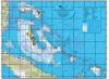
Each Explorer Chartbook's back cover gives you a pictorial sketch of the chart coverage for a general overview. It refers you to specific small-scale charts for planning and large-scale charts for navigating. In planning your entire cruise or just an island hop, first look at the small- and medium-scale charts of the particular area for an overall perspective; then refer to the large-scale charts for details and closeups, as well as essential "Need-to-Know Info" to help you locate what you need ashore.
About the Authors
Authors Monty and Sara Lewis cruise the Bahamas in their trawler SARANADE. With a love for the Bahamas and the help of their shoal-draft vessel and GPS technology, they have spent many winter seasons creating these charts and Quick-Reference Guides to make it easier and more pleasant for cruising folks to enjoy a taste of paradise so close to mainland North America. Monty grew up in the waters around Ocean City, Maryland, and he and Sara conducted summer daysailing trips for shoreside visitors in their sloop VIVACIOUS for 12 years. Monty has held a U.S. Coast Guard License for 30 years and is a past commodore of the Eastern Shore Sailing Association and a member of the Delaware Capes Sailing Club. Sara's USCG Captain's License and her background in English and journalism have helped her in preparing the Quick Reference Guide text. |